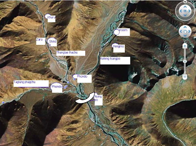
This project is documented in our last map of Hydropower Projects on the Yarlung Tsangpo (Brahmaputra) river. This is only one of the many, many dams that will be built on the Tibetan Plateau. Tens of thousands more will be forcefully displaced from their homes to make way for these projects. What makes this situation really gloomy is that this news story, for example, did not come to the attention of most Tibetan internet users and Tibetan rights activists sooner. In the past we could blame lack of information and news from Tibet for our ignorance, but today we have such amazing technological tools as Google Earth at our disposal that can be effectively used for our information-sharing and advocacy work. Here's an example:
Someone has posted these some colorful still shots from what seems like a video clip on Google Earth:


These pictures, including some of the construction equipment, were probably taken by tourists visiting the area. All of these photos are from Google Earth:


Check out the comment posted by one of the visitors to the site:

Check out these Google Earth images of the area. The first two annotated images are from my colleagues at the Central Tibetan Administration's Environment and Development Desk. The remaining images, some of them are from November 8, 2008 and some of them are as recent as March 13, 2010. These images clearly show the villages and the fields, which will be inundated by the reservoir or developed beyond recognition. If only someone would archive all of these Google Earth images of Tibetan villages and pastoral lands before they are developed and their images updated on Google Earth.


If you would like to read some Tibetan language news from China, see this, this, this. You can get these news stories by doing a google search of "????????" (phod mdo or Phondo).
{ 0 komentar... read them below or add one }
Posting Komentar