Tampilkan postingan dengan label dam. Tampilkan semua postingan

Tibetan language map of Tibet Autonomous Region

Diposting oleh Unknown on Senin, 30 April 2012

The Tibetan Plateau blog is pleased to make the most detailed Tibetan language map of the Tibet Autonomous Region (TAR) we have seen so far available for download.
 
Although this is a relatively old map, published in 1981 by the TAR Bureau of Cartography, it is the best we have seen in terms of detail, showing settlements down to the level of villages below the township level. The map also shows roads, railway lines, hydro-dams and environmental features such as glaciers, desert, lakes and springs. Here are examples of the amazing level of detail in the map. The scale of the map is 1: 1000000.
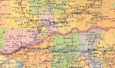
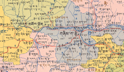
A warning before you download the map: this is a huge (25 MB) JPEG file. If your computer has sufficient storage space and other resources, you can download the map here.

We hope that this map will be useful for students, researchers and others who are interested in Tibet.

With thanks to all the readers for their interest and support.
More about → Tibetan language map of Tibet Autonomous Region

Monitoring Tibet through Google Earth - 2

Diposting oleh Unknown on Kamis, 16 Desember 2010

A couple of quick updates: Zhikhong and Thrangu Dam

Last year, Tibetan Plateau blog reported a doctored Google Earth image, which suspiciously covers the Zhikhong Dam, located approximately 100 km NE of Lhasa. While Google did not respond to my queries, the company has now uploaded a different, untampered image of the dam. See below.


THRANGU DAM
In April 14, 2010, a huge earthquake hit Yushu County and caused massive destruction to life and property. The tremors had also damaged a dam, threatening to flood the main city located downstream.

Google Earth has uploaded a April 28, 2010 image of the dam, which shows the reservoir mostly empty.


Check out these images on Google Earth yourself! Notice the coordinates (latitude and longitude) at the bottom of most GE images posted on this blog. Share what you find with us and your friends!

More about → Monitoring Tibet through Google Earth - 2

Monitoring development and sharing information through Google Earth

Diposting oleh Unknown on Sabtu, 11 Desember 2010

A friend forwarded this news story to me. About 3000-4000 Tibetans will have to leave their ancestral homes and villages to make way for a hydro-power project near Lhasa's Lhundrup county in a place called Phondo (????????). Most of these people are agro-pastoralists. The farmers have been ordered to leave their homes by next year and that they cannot practice their traditional livelihood there any more. Farmers are worried that they will be forced to sell their animals and relocated to separate areas. Their requests for better relocation plans have been ignored. According to the report, all of the construction workers that have moved into the region are Chinese and there are a few thousand soldiers now stationed at the site.

This project is documented in our last map of Hydropower Projects on the Yarlung Tsangpo (Brahmaputra) river. This is only one of the many, many dams that will be built on the Tibetan Plateau. Tens of thousands more will be forcefully displaced from their homes to make way for these projects. What makes this situation really gloomy is that this news story, for example, did not come to the attention of most Tibetan internet users and Tibetan rights activists sooner. In the past we could blame lack of information and news from Tibet for our ignorance, but today we have such amazing technological tools as Google Earth at our disposal that can be effectively used for our information-sharing and advocacy work. Here's an example:

Someone has posted these some colorful still shots from what seems like a video clip on Google Earth:


These pictures, including some of the construction equipment, were probably taken by tourists visiting the area. All of these photos are from Google Earth:


Check out the comment posted by one of the visitors to the site:


Check out these Google Earth images of the area. The first two annotated images are from my colleagues at the Central Tibetan Administration's Environment and Development Desk. The remaining images, some of them are from November 8, 2008 and some of them are as recent as March 13, 2010. These images clearly show the villages and the fields, which will be inundated by the reservoir or developed beyond recognition. If only someone would archive all of these Google Earth images of Tibetan villages and pastoral lands before they are developed and their images updated on Google Earth.


If you would like to read some Tibetan language news from China, see this, this, this. You can get these news stories by doing a google search of "????????" (phod mdo or Phondo).
More about → Monitoring development and sharing information through Google Earth

Times of India: Response from Chinese official

Diposting oleh Unknown on Rabu, 26 Mei 2010

The Times of India has published an article in response to the recent article by the Guardian about hydropower projects in Tibet. The Guardian's article is based on my last blog post. The Times of India has interviewed a Chinese official, Ma Jiali, with the goverment-run Institute of Contemporary International Relations to respond to a claim (which I also made) that China is likely to build a massive 38 gigawatt hydropower project at the Great Bend of Yarlung Tsangpo-Brahmaputra river.


It is a privilege to have one's work discussed in major newspapers like the Guardian, Times of India and the Hindustan Times! Thanks to the reporters who did the stories to bring much needed attention to this important matter.

I wanted to write directly to Times of India with a response to Mr. Ma Jiali's comments but surprisingly I couldn't find a "Contact" link/info on their website! So here is a blog post instead.

Mr. Jiali's response: "There are some people in China including hydrological engineers and retired military officers pushing the government to build a major water project on the Brahmaputra in Tibet. But the Chinese government has no such plans. [...] Some people including retired military officers have been advocating such a project for a long time. But I can tell you there is no such plans in the government."

Yes, we knew that. However, it must be clarified that there are two components to the "major water project" discussed here: one is hydro-power project and the other is a connected water diversion project to China. My claim is that the hydropower project is likely to be built but the water diversion project is not very likely. Read my last blog post for more details.

Mr. Jiali continues: "All that the government wants to do is establish small hydro-electricity projects in a way that there is no environmental damage. It will be bad for China as well because such a project can cause serious damage to environment in the sensitive mountain areas. Also, where is the market for generating so much electricity in Tibet?" And Times of India adds, "A major project would not be economically viable."

Now this is not true and is very misleading. The Tibetan Plateau blog has identified at least 16 hydro-electricity projects on the Yarlung Tsangpo and its tributaries that can generate more power than the largest hydropower project currently operating in Tibet Autonomous Region, the 100 MWZhikong project near Meldro Gungkar (???????????????).

Certainly there is no domestic demand for so much energy, except to power government's extensive plans to develop the region and to extract gold, copper and other minerals. The greatest demand for energy actually comes from Chinese cities. A senior researcher like Mr. Jiali cannot be ignorant of China's "West to East Power Transmission Project." Here is the State Grid map again, which shows Metog (Motuo) hydropower project connected to ultra-high voltage power transmission lines of China.


More about → Times of India: Response from Chinese official

Damming Tibet's Yarlung Tsangpo-Brahmaputra and other South Asian rivers

Diposting oleh Unknown on Senin, 24 Mei 2010

The Tibetan Plateau blog presents a preliminary map of hydropower projects on the upper reaches of the Tsangpo-Brahmaputra (????????????????) River in Tibet. It is hoped that this map will contribute new information to recent international discussions and clarify some of the misunderstandings about Chinese water control projects on the river.


Click on images for full size view


The map also shows hydropower projects (HPP) on the upper reaches of several other international rivers in South Asia, namely the Indus (Senge Khabab), Sutlej (Langchen Khabab), Karnali (Mabcha Khaba), Arun (Bumchu) and Subansiri (Loro Chu/?????????, alternative name: Jya Chu/??????) rivers. This is the final map in a series that shows hydropower projects on the Tibetan Plateau.** Previous maps include those on the upper reaches of the Salween, Mekong and Yangtze rivers; the Yellow River; the Nyagchu or Yalong River; as well as the eastern edges of the Tibetan Plateau. As always, corrections as well as additions to any of these maps are most appreciated.

The status of dams on the upper reaches of Yarlung Tsangpo-Brahmaputra shows that there are 10 dams completed, three under construction, seven under active consideration and eight more proposed. There is one hydropower project completed, each, on the Senge Khabab (Indus), Langchen Khabab (Sutlej) and Mabcha Khabab (Karnali) rivers. Five large dams are proposed on the Bumchu (Arun) River and another large dam proposed on Loro Chu (Subansiri).

While the larger hydropower projects and a few of the smaller projects have been indicated, there are many small hydropower projects in the region, disconnected from any large power grids. Many Tibetans have until recently lived without electricity, and many still do. There is a pattern by which dams and power transmission lines are built on the Tibetan Plateau -- smaller and middle sized dams are built first, to provide a basis for the construction of larger ones to follow. The current push to provide Tibetans with electrical power seems primarily motivated by the need for larger HPPs to power resource extraction, infrastructure development, and ultimately for supply to coastal Chinese cities where demands are the highest.

A note on Tibetan and Chinese names on the maps: The maps show Tibetan names of places, rivers, mountains and lakes. However, HPPs are indicated with their Chinese names unless they are not known. The Chinese names are used mainly because these are Chinese projects better known with their own project names and also because it is easier to locate (less confusing) for researchers.

YARLUNG TSANGPO-BRAHMAPUTRA
The Tsangpo-Brahmaputra is a major international river shared between Tibet/China, India and Bangladesh. On the Tibetan Plateau, the river flows west to east, across Southern Tibet, from its sources near the sacred Mt. Kailash (??????????????) all the way to the Great Bend, where the river turns north to take a sharp U-turn to flow south into India and then to Bangladesh. Hydrologically, this river is connected to the larger Ganges-Brahmaputra-Meghna basin.

Until recently, the Yarlung Tsangpo was considered as an undammed river. China has officially announced plans to build five dams on the middle section of the river, including the Zangmu project currently under construction, which has caused much concern in India. The absence in these debates of the voices of Tibetans who live in the valley and are traditional users of its waters in these debates is deplorable, especially given their historical, religious and economic connections to the river.

The Yarlung Tsangpo River is intimately linked to the history of Tibetan civilization, indigenous religious beliefs and practices, and ultimately to the Tibetan identity. As the River Nile is to Egypt, Yarlung Tsangpo can be considered the cradle of Tibetan civilization. The Yarlung Valley is the home of the earliest Tibetan kings known as the Yarlung Dynasty. From its sources near the sacred Mt. Kailash, the Yarlung Tsangpo valley is dotted with pilgrimage sites and power-places such as meditation caves of past masters and beyul (?"hidden valleys") for spiritual practices. The river is also shown in paintings of the famous imagery of Tibet as a supine demoness (????????????????).


THE TSANGPO GORGE: THE SACRED LAND OF PEMA KOE
The Great Bend of the Yarlung Tsangpo, also known as the Tsangpo Gorge, has attracted significant international attention as the "Last Secret Place on Earth" and for having the greatest hydropower potential of any site in the world. Through the 19th century, cartographers were not certain whether the Yarlung Tsangpo emerged from the other side of the Gorge as the Brahmaputra, the Irrawaddy, or some other river. Just downstream of Lungpe (????????), the Yarlung Tsangpo enters one of the world's deepest and largest gorges, starting from a 4,900-meter cleft between two of the highest mountains in Eastern Himalaya: 7756 meters high Namchak Barwa and 7294 meters tall Gyala Pelri. As the river drops nearly 2500 meters in altitude through the length of the bend, the gorge is considered ideal for hydropower generation. Speculation about the construction of the world's most powerful dam and a major water diversion project at this site (discussed below) has been a major cause of concern in downstream countries.

The Great Bend of the Yarlung Tsangpo River is also known as one of the most bio-diverse regions in the world in terms of plant species. Although it is hard to imagine how botanists studied and added up the numbers of different plant species in this hard-to-travel corner, this official site boasts the existence of 3,700 plant species and emphasizes "the primordial nature of the plants" in the region. The ecological integrity of the Great Bend area is critical for the conservation of the Himalayas as one the world's richest but at greatest-risk areas for biodiversity (hotspot).

To the Tibetans, the Great Bend region is known as Pema Koe, the most sacred beyul blessed by Guru Rinpoche, Padmasambhava, the Indian Buddhist yogin credited with firmly establishing Buddhism in Tibet. Generations of visionary Tibetan Buddhist masters have revealed "hidden treasures" (???????) and made journeys through the different layers of spiritual doors of beyul Pema Koe. Tibetans also consider the region as the home of the Goddess Dorje Phakmo (Vajra Yogini).

Similar to the Tibet map depicted as a demoness lying on her back, this local trekking group describes the sacred geography of the Pema Koe region as mapped onto the body of the goddess Dorje Phakmo herself: "Her head is the Kangri Kangpo [White Snow Mountain], her two breasts [are] Namche Barwa and Gyala Peri [mountains] respectively. The lower part of her body lies in Yangsang or the innermost Pemako which is the upper Siang region of Arunachal Pradesh. In the confluence of Siang (Tsangpo) and Yangsang is the sacred tri[a]ngle Kila Yangzom the vulva of Goddess Dorje Phagmo." These beliefs and pilgrimage practices have religious and cultural significance for millions of Buddhists around the world.


The Great Bend of the Tsangpo-Brahmaputra. Photo courtesy of Christoph Hormann of www.imagico.de

HYDROPOWER PLANS AT THE GREAT BEND OF THE YARLUNG TSANGPO-BRAHMAPUTRA
The map shows two different proposals to harness the hydroelectric potential of the Great Bend: Motuo and Daduqia. The tunnels for Motuo project starts at Lungpe and ends at Metog (???????). Daduqia starts near Pe (???) and ends at Digdong (??????????) near the Indian border. Of these two projects, China is likely to build the 38,000 MW hydropower station near Metog called Motuo in Chinese. This project is feasible from an economic and engineering perspective, although there will be major environmental and seismic issues involved due to the size of the reservoir if the Chinese government decides to build a large dam at the lower end of the tunnels. The status of the project shown as under active consideration is based on informed assessments and evidence. The project is likely to be built after related infrastructure of nearby dams to supply power for its construction and ultra-high voltage power transmission lines are completed. Although the July 2003 Xinhua reports of preliminary studies conducted in the region are not available online anymore, there are several evidences online including discussions of the project on official, academic and other professional websites. The following annotated map of the State Grid Corporation of China envisions the Motuo project connected to ultra high voltage lines of China.


Any tunnels associated with hydropower projects would be approximately 15 - 25 km long, of similar length to those currently being constructed for the Jinping II project on the Nyagchu. These proposed tunnels would likely be attached to large pipes on the downstream side to convey the water through a number of generators before reaching the lower leg of the bend. At this point it is likely that there would also be a large dam (Motuo) in the Grand Canyon of the bend. An alternative proposal, shown on the map as "Daduqia", avoids large dams altogether and takes full advantage of the 2400m drop in altitude, but it is near the border with India and would be highly exposed if there were another conflict. The details of the tunnel routes as presented on the map are inferred but are presented with high confidence based on the assumption that China's engineers have sought to optimize the return on the project.

The greatest risk to a large dam at the Great Bend comes from seismic activity. The Himalayas and the Tibetan Plateau were formed by the collision of techtonic plates. As such, earthquakes are not uncommon in Tibet. Metog County, where Motuo reservoir is likely to be built, had a "moderate" earthquake in 2008 before the disastrous Sichuan Earthquake that killed over 90,000 people. The recent earthquake in Yushu and the cracking of Thrangu dam is a nerve-wracking example for people living downstream in India and Bangladesh, given the proximity of the Great Bend to India. Chinese government seismologist Fan Xiao has suggested that man-made activity such as the weight of a large artificial lake near fault-lines can trigger earthquakes.

WATER DIVERSION FROM THE TSANGPO-BRAHMAPUTRA RIVER
Several ideas have been proposed to divert water from a giant dam at the Great Bend, through hundreds of kilometers of long canals, to the Yellow River, the Yangtze River, or even the Gobi Desert. Two individuals are key sources of these ideas: Guo Kai, a retired Chinese People's Liberation Army general, whose ideas were published in a book titled "How Tibet's Water Can Save China" by Li Ling (published December 2005), and the late Mr. Masaki Nakajima, "founder and special advisor to the Mitsubishi Research Institute of Japan," who first proposed a $500 billion project to the Global Environmental Fund in 1977 (See, Verghese in "Waters of Hope", 1990, pp. 188-189). These proposals are not shown on the map because there is no evidence of government interest and also because these ideas do not make practical or economic sense.

While Masaki Nakajima and Guo Kai were the two main sources of speculation, there are actually many different proposals for diverting water from the Tsangpo-Brahmaputra. The only project that had "official" interest at one time envisioned diverting water from near Tsethang, in the mid-reaches of the river at about 3500m, and directing it through a tunnel into the Nyang valley, and from there eventually to the Yellow River. It would rely on both gravity and power generated by a HPP on the Great Bend to move the water to the intended location. This project has been officially dismissed. There are other "unofficial" proposals, including connecting different rivers of Tibet as if these were streets that can run in all directions.

Close study of the terrain around the Great Bend area and possible canal routes on Google Earth show that the laws of physics will not allow water diversion from the Great Bend as suggested. For example, a reservoir like Motuo (850 m altitude) which is ideal for taking advantage of the drop in the Great Bend altitude would have lost 2000 meters of height that must be transferred over corrugated mountain ranges--through canals that are hundreds of kilometers long. Some may stubbornly argue that it is possible to divert the water with the combined power supplied by the dams at Motuo and Yiwong-Parlung rivers and with "peaceful nuclear explosions" to bore tunnels in the mountains. Even if these were possible, the immense costs do not make sense given the fact that water can be diverted from other rivers more easily and the key attraction for power generation at the Great Bend is economic development, not pumping water. Another major issue is the climate of the Tibetan Plateau, where it is below freezing point during winters and during early spring when water demand is highest in North China.

The Mid-Reaches of the Yarlung Tsangpo
This is where major development is currently taking place. The 510MW Zangmu (???? or Zam) is under construction and three other projects, Lengda (????????? or Lingda), Zhongda (?????????? or Zhomda), and Langzhen have begun site preparation. Construction could begin within a few years. Development of Jiacha (?????? or Gyatsa) is also expected soon. It appears Jiexu will be developed last. As this is the upstream dam in this cascade of six projects, and the last to be developed, this may have a large reservoir to assure a constant flow for the downstream dams.

Here is an annotated high-resolution image of Zangmu project under progress from GeoEye that is annotated by one of Tibetan Plateau blog's consultants. Tibetan Plateau blog is responsible for the annotation.


The Yiwong and Parlung Rivers
Site planning is currently under way on these tributaries of the Yarlung Tsangpo. Completion of projects on these rivers is likely required for development of the Motuo HPP. The sites indicated are based on a map on Hydrochina's website. As the characters of the names of most of the projects shown were unintelligibly small and vague on the Hydrochina map they have been assigned the Tibetan names of nearby towns, which are approximate sites of future developments.


**The Tibetan Plateau blog is grateful to many individuals and organizations for their support and guidance in making this series of maps possible for publication. Organizations include International Rivers, Probe International and the University of British Columbia. People include friends and experts living/working in Tibet and China, Kevin Li, Bruce Lee, James Trevor, Stone Routes, Dorothy Berger and most of all to M, who did most of the laborious work behind these maps. Thank you all!

More about → Damming Tibet's Yarlung Tsangpo-Brahmaputra and other South Asian rivers

India poorly informed about Chinese dam project

Diposting oleh Unknown on Senin, 26 April 2010

In recent days, Indian media has been running a story that China has "admitted" that it is building a dam (Zangmu) project on the Yarlung Tsangpo (Brahmaputra River). It is rather frustrating for me to read or comment on this development because this should not be "news" and there is a lot of misinformation being spread around in the media and on the web.

China acknowledging that it is building the Zangmu hydropower project should not be "news" because the project has long been openly advertized in Chinese media, including official websites. There should not be any question of admission about things that are open public knowledge. Tibetan Plateau blog reported on the construction of Zangmu dam more than a year ago, in English! Indian reporters surely know how to use google.

India came to know about construction of Zangmu project after its "intelligence agencies" received satellite images of construction work going on for the Zangmu project last fall. This was widely (mis)reported in Indian media late October 2009. I suppose the Indian External Affairs Minister, the person who brought the "news" from his Chinese counterpart, raised Indian concerns about the Zangmu project based on these satellite images. Indian reliance on vague satellite images as some kind of evidence is really embarrassing because chinese official websites have been carrying clear photos of Zangmu construction work (see below) and models of completed project for a long time.


Then there is the issue of serious misinformation. In my previous post on misinformation about Zangmu project, I identified confusions about Zangmu project's location and use as a water diversion project. The same confusion continues, here and here are a couple of examples.

Indian media and online writers cannot be blamed too harshly for treating this as "news" and being confused about location of the project, even Hong Kong based South China Morning Post is in the same boat. Zangmu project is located in the middle reaches of Yarlung Tsangpo on the Tibetan Plateau in dZam (????) township of Lhokha (Shannan) Prefecture of Tibet Autonomous Region, about 140 km southeast from Lhasa, between Zangs-Ri (Sangri) and rGya-Tsha (Jiacha) counties.

Here is a high resolution image of Zangmu project under progress from GeoEye that is annotated by one of Tibetan Plateau blog's consultants. Tibetan Plateau blog is responsible for the annotation.


Tibetan Plateau blog will soon be posting a map of planned hydropower projects on the Yarlung Tsangpo river. There are more than the five projects "admitted" by China that are planned on the river. Stay tuned.
More about → India poorly informed about Chinese dam project

Thrangu dam: safe for now

Diposting oleh Unknown on Kamis, 22 April 2010

According to reports, a dam near Thrangu (???????????? or "Changu" in Chinese media) monastery has been damaged. Many people, including nomads, had fled higher up into the mountains out of fear that the dam might collapse and the water in its reservoir will destroy the town of Jyekundo (????????????) or Yushu (??????? / ?????????).

This report from The Independent indicates that the dam is sitting like a time bomb that might cause another tragedy: "Emergency officials said the dam could burst at any time, putting 100,000 people in danger".

Thankfully it seems like the water in the reservoir of the dam has been drained and Jyekundo is safe for now.

Imagine what would have happened if the dam had bursted and its water swept the town of Yushu, minutes after the earthquake? Such concerns should be a wake up call for Chinese authorities to reconsider their dam building plans on the Tibetan Plateau, much of which is affected by seismic zones. See here, here and here for China's plans for hydropower development on the Tibetan Plateau.

Below are three Google Earth satellite images (click for larger view) of the dam and the town of Yushu. According to Google Earth, Yushu or Jyekundo is at an altitude of 3,685m and the upstream dam, located South, is at an altitude of 3,800m.


More about → Thrangu dam: safe for now

Earthquake in Yushu

Diposting oleh Unknown on Rabu, 14 April 2010

See the last section for ways you can donate to help with the relief work

A nice Tibetan song dedicated to the earthquake victims


Google has added some useful tools to support earthquake disaster relief in Yushu. And for regular real time updates (even better than tweeter), check this link. Here are some informative satellite images from google. Click to make images bigger.

GeoEye GE-1 high resolution satellite imagery of Yushu after the earthquake


USGS Shake Map showing different colors for different intensity levels of tremor


Surface acceleration


Damage intensity


Click on this link to see Kyegu Monastery relief work album. Lots of pictures.

Xinhua reports China is carrying out a geological reconnaissance for the rebuilding of the quake-hit township of Jyekundo, to be turned into "a plateau ecological tourist city."

Tibetan language map the region


Websites specifically dedicated to providing information on the ongoing situation and relief work:

Special website of local consortium of NGO's, now active in
Jiegu, Xining and Chengdu.

Plateau Perspectives is one the best sources of updates on the situation on the ground. See this special website.

University of Virginia also has a special website.


This photo of a girl reading her book in front of earthquake ruins is really something. Photo from pourmecoffee.com.


Al Jazeera report on cremations for the dead:


Here are three Google Earth images (Thanks Nima-la!) of the damaged dam near Thrangu (???????????? or "Changu" in Chinese media) monastery. The first two images show the town of Yushu (??????? / ?????????) or Jyekundo (????????????) at an altitude of 3,685m and the dam located South, upstream at an altitude of 3,800m. The second is a close image of the dam. This report from The Independent says that "Emergency officials said the dam could burst at any time, putting 100,000 people in danger". This dam is like a time bomb that might cause another tragedy. I urge governments, groups and citizens of China to urge China to use its resources to gradually empty the reservoir, secure the dam and take people living downstream away to safer areas.


The following images are from a Chinese language blog.


For more images from the same source (warning: disturbing images of dead victims), click here

lhatseri tweets: "Tibetan language blogs sites from PRC have been blocked. No posts about the earthquakes."

Death toll rises to 589, according to China Daily

A "Letter from China" in the New Yorker talks about China's news censorship about the earthquake

The International Rivers has raised timely concerns about dam safety and questioned the sensibility of proposed dam projects in the region.

A set of still images from the Telegraph also shows aid work going to the region.

This New York Times video shows a different set of clips.

High Peaks Pure Earth has translated Tibetan netizen reactions to the earthquake. More here.

Chinese language CCTV report


Two English language news reports available on youtube:


For more information, see these stories from Xinhua and BBC. For technical information about the tremors, see this US Geological Survey site.


==================
SUPPORT RELIEF WORK BY DONATING TO ORGANIZATIONS THAT WORK IN THE REGION

1. Donate to Tibetan Village Project's earthquake relief fund by clicking here

2. Another NGO working locally is Machik. You can donate to Machik's earthquake relief fund by clicking here

3. Tibet Foundation


More about → Earthquake in Yushu